Posted: April 17, 2025 – 1:00 AM CDT
Author: Collin Leck, MWSC Ops Desk
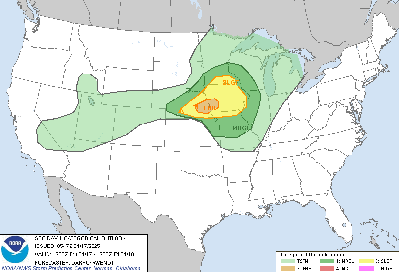
The Storm Prediction Center has upgraded parts of the Central Plains to an ENHANCED RISK for severe thunderstorms today, Thursday, April 17, 2025. Storms are expected to develop late this afternoon and evening along a strong cold front moving through eastern Nebraska and western Iowa.
🧭 Forecast Overview
A large upper-level trough continues to advance through the western U.S., promoting strengthening wind fields and an approaching cold front. Boundary layer temperatures are expected to rise into the mid-80s this afternoon across southeast Nebraska, leading to CAPE values exceeding 2500 J/kg, favorable lapse rates, and robust shear. These conditions will support the development of scattered supercells capable of:
- ⚠️ Large to Very Large Hail (2+ inches)
- 💨 Localized Damaging Wind Gusts
- 🌪️ Conditional Tornado Threat – especially near the triple point in eastern Nebraska
📍 Target Area
The greatest risk includes:
- Southeast Nebraska (Omaha, Lincoln, Beatrice)
- Southwest to Central Iowa (Council Bluffs, Red Oak, Creston)
- Extending northeastward into southern Minnesota later this evening
🕒 Timing
| Time Frame | Threat |
|---|---|
| Morning – Midday | Calm, strong heating begins south of the front |
| 4:00–6:00 PM CDT | Initial storm development likely across southeast Nebraska |
| 6:00–9:00 PM CDT | Peak supercell window with hail/tornado potential |
| 9:00 PM – Midnight | Elevated convection possible; hail risk continues |
🔭 Key Factors to Watch
- Dewpoints reaching the upper 50s – enhancing tornado potential
- Frontal location and dryline bulge positioning
- Strength of low-level jet and capping inversion after dark
📢 Operations Update
MWSC will continue monitoring visible satellite, surface observations, and short-range models throughout the morning. A final deployment decision will be made by 1:00 PM CDT.
Follow us for live updates throughout the day on:
➡️ Facebook
➡️ Discord
➡️ YouTube
Stay weather-aware. This is a dynamic setup and storm potential is significant.

More Stories
🌪️ Severe Weather Outlook – Monday, May 19, 2025
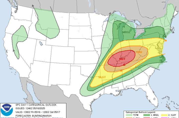
🌀 Midwest Storm Chasers – Day 1 Severe Weather Forecast📅 Valid: Friday, May 16, 2025 | 7:00 AM CDT – Saturday, May 17, 2025 | 7:00 AM CDT📍 Target Regions: Mid-Mississippi Valley, Ohio Valley, Tennessee Valley
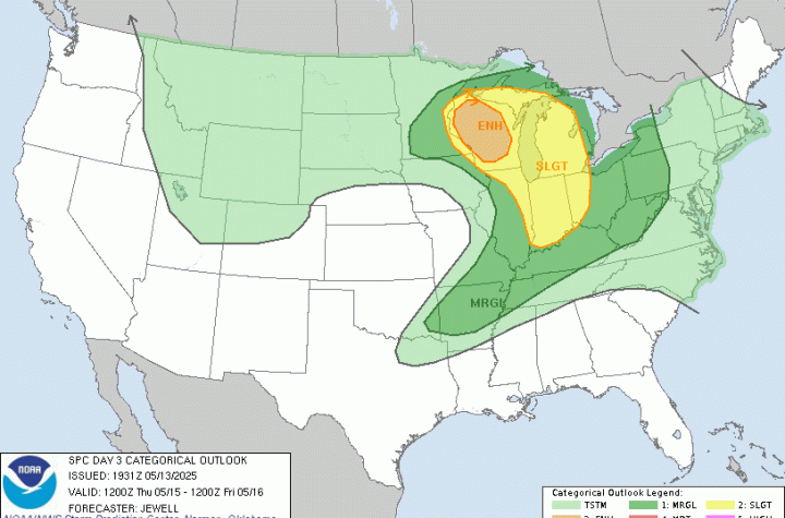
🌀 Midwest Storm Chasers Ops Desk Forecast📅 Day 3 Convective Outlook📍 Valid: Thursday, May 15, 2025 | 7:00 AM CDT – Friday, May 16, 2025 | 7:00 AM CDT📌 Issued: May 13, 2025 – 2:45 PM CDT📍 Lead Forecaster: Collin Leck