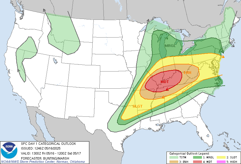
⚠️ Overview: MODERATE RISK Issued
A regional outbreak of severe weather is likely today into tonight across portions of the Mid-Mississippi, Ohio, and Tennessee Valleys. All severe hazards are on the table, with strong tornadoes, very large hail, and destructive wind gusts expected. A long-track, high-end tornado is possible, especially across southern Illinois/Indiana, southeast Missouri, western Kentucky, and southwest Ohio.
🌪️ Key Threats
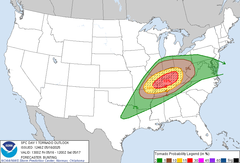
Tornadoes: Several tornadoes are likely, with the potential for multiple strong (EF2+) tornadoes. A long-track tornado cannot be ruled out.
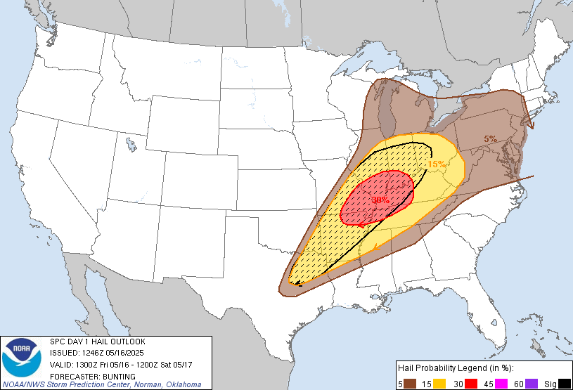
Hail: Scattered reports of large to very large hail (2–3 inches in diameter) likely with supercells.
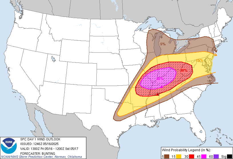
Wind: Severe wind gusts exceeding 75 mph are expected, particularly as storms organize into bowing segments tonight.
⏰ Timeline & Storm Evolution
Morning – Early Afternoon (Now to ~2 PM CDT):
Ongoing strong to severe thunderstorms across northeast Arkansas, western Kentucky, and parts of Tennessee may pose hail and wind threats, potentially tracking into West Virginia and Virginia by afternoon.
Destabilization resumes behind this activity with warm, moist air surging north.
Afternoon – Early Evening (~2 PM to 7 PM CDT):
Explosive storm development is likely by early afternoon over eastern Missouri, extending into southern Illinois and Indiana.
These storms will rapidly intensify into discrete supercells, capable of producing strong tornadoes, destructive hail, and severe winds.
Greatest tornado potential will be across the Moderate Risk corridor, where strong low-level shear and rich instability overlap.
Evening – Overnight (~7 PM to 2 AM CDT):
Supercells will congeal into one or more QLCSs (bowing lines) as they move eastward into Kentucky, Indiana, Ohio, and Tennessee.
This transition will maintain the threat of tornadoes—particularly QLCS spin-ups—as well as a heightened damaging wind threat, possibly exceeding 75 mph.
🌡️ Meteorological Setup
Instability: MLCAPE values of 2500–3000 J/kg are expected across much of the warm sector.
Shear: Deep-layer shear of 50+ knots, with enhanced low-level helicity near the warm front.
Trigger: Strong upper-level forcing from an incoming trough, surface low over the Midwest, and lifting warm front.
📍 Secondary Risk Areas
Ark-La-Tex into Northeast TX:
Late-day development (after 5 PM) along the trailing cold front may yield isolated supercells producing giant hail, damaging winds, and a low tornado threat.
Mid-Atlantic (SE PA, NJ, Delmarva):
Redevelopment possible this afternoon from remnant MCS activity. Isolated supercells may form with a risk for hail and damaging winds, but coverage and intensity remain uncertain.
🎯 Chaser & EM Notes
Chase Target: Initial focus should be on eastern Missouri into southern Illinois and western Kentucky by early afternoon.
Safety Notice: The risk of nocturnal tornadoes and QLCS winds will increase significantly into the evening hours across the Ohio Valley, posing elevated hazards for the public.
Coordination: Emergency services should remain on high alert, with surge plans in place for tornado warnings and power outage scenarios.
📡 Next Update: A short-term nowcast will be issued as convective initiation nears.
Stay tuned and stay safe,
— Midwest Storm Chasers Forecast Division
More Stories
⚠️ Special Weather Statement – Rusk; Panola – Sunday, July 12, 2026
⚠️ Flash Flood Warning – Armstrong, TX; Randall, TX – Sunday, July 12, 2026
⚠️ Special Weather Statement – Sevier; Howard; Little River; McCurtain – Sunday, July 12, 2026