MWSC Forecast – Day 1 Outlook (Saturday, April 19, 2025)
Forecaster: MWSC Ops Desk
Summary
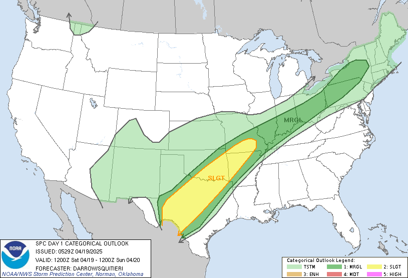
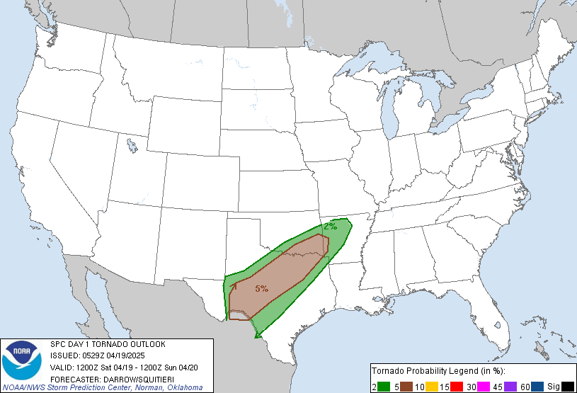
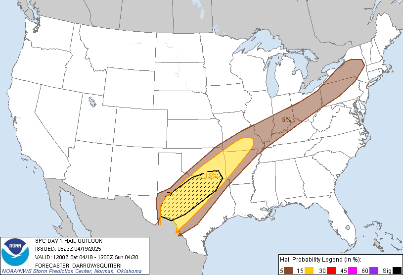
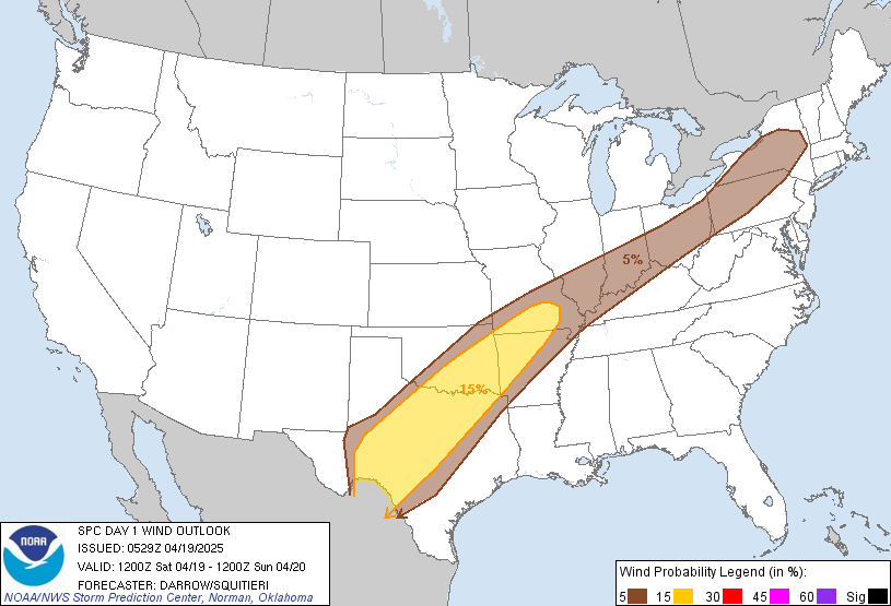
Today, we are monitoring a slight risk of severe thunderstorms extending from Texas to southern Missouri. Scattered strong to severe storms are expected, with the potential for large hail, damaging winds, and isolated tornadoes, primarily in north-central Texas. Additionally, isolated strong storms may impact areas from the Ohio Valley into portions of upstate New York, where strong winds and hail are possible.
Setup
A dynamic weather pattern is in place as a well-defined upper-level low digs southward into northern Arizona, forecasted to settle into southern New Mexico. This system will eject into the southern Plains overnight, interacting with a series of weak disturbances embedded within the southwesterly flow from northern Mexico to the Mid-Mississippi Valley. The presence of a frontal zone will enhance low-level warm advection, contributing to storm development.
Currently, clusters of elevated convection are persisting from Oklahoma into southern Missouri. These storms may gradually shift southward into northern Texas as the cap weakens throughout the day. Strong wind profiles along the frontal corridor suggest organized updrafts, including supercells capable of producing large hail and perhaps tornadoes, especially for any surface-based storms south of the wind shift.
Timing
- Morning to Early Afternoon: Elevated convection will continue from Oklahoma into southern Missouri, potentially extending into northern Texas.
- Late Afternoon to Evening: Strong boundary-layer heating from far west Texas into the Edwards Plateau will breach convective temperatures along the dry line. Expect supercells to develop and track northeast toward north-central Texas, with large hail and tornado potential.
- Overnight: As the upper trough approaches, a low-level jet (LLJ) will intensify across northern Texas into eastern Oklahoma. A surface low is expected to track into southern Oklahoma by Sunday morning. If sufficient buoyancy is maintained, severe storms may persist in this area.
Areas to Watch
- North-Central Texas: Highest risk for supercells with large hail and tornadoes. Monitor for potential upgrades in severe probabilities if the frontal zone remains favorable for surface-based storms.
- Eastern Oklahoma to Southern Missouri: Continued risk for organized clusters with damaging winds and hail.
- Ohio Valley to Upstate New York: Watch for scattered convection ahead of a cold front, with potential for strong wind gusts and hail.
Mesoscale Considerations
- Frontal Zone Positioning: The exact position of the frontal zone will be crucial in determining the extent of surface-based storm development. A southward shift could increase the likelihood of elevated storms, while a more northerly position favors severe weather potential.
- Cloud Cover and Precipitation: Extensive clouds and ongoing precipitation may limit instability in some areas, but breaks in the clouds could enhance severe potential.
Awareness and Deployment: Stay informed and prepared for rapid changes in storm intensity and coverage throughout the day. For those in the highest risk areas, monitor local weather updates and be ready to deploy if conditions warrant. Remain vigilant for any updates to the severe weather outlooks, as mesoscale features may prompt changes in risk levels.
Stay safe,
MWSC Ops Desk

More Stories
🌪️ Severe Weather Outlook – Monday, May 19, 2025
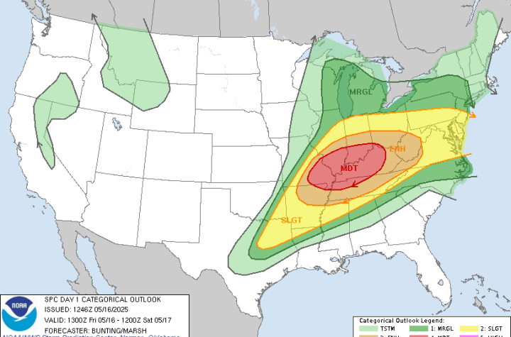
🌀 Midwest Storm Chasers – Day 1 Severe Weather Forecast📅 Valid: Friday, May 16, 2025 | 7:00 AM CDT – Saturday, May 17, 2025 | 7:00 AM CDT📍 Target Regions: Mid-Mississippi Valley, Ohio Valley, Tennessee Valley
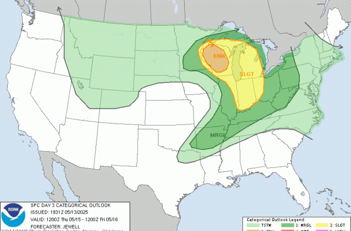
🌀 Midwest Storm Chasers Ops Desk Forecast📅 Day 3 Convective Outlook📍 Valid: Thursday, May 15, 2025 | 7:00 AM CDT – Friday, May 16, 2025 | 7:00 AM CDT📌 Issued: May 13, 2025 – 2:45 PM CDT📍 Lead Forecaster: Collin Leck