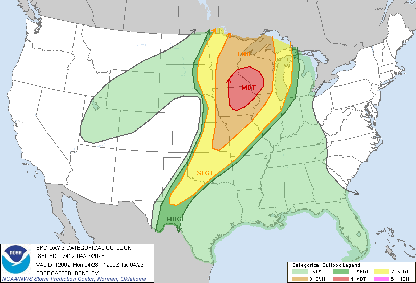
Issued: April 26, 2025
Prepared by: Midwest Storm Chasers
🌪️ Key Headlines:
- Moderate Risk (Level 4/5) issued by the SPC.
- Tornado outbreak possible, including the threat for strong to intense tornadoes.
- Large hail and widespread damaging winds are also major threats.
- Severe weather will likely impact areas from central Iowa into southeast Minnesota and western Wisconsin.
🌡️ Atmospheric Setup:
A strong mid-level jet streak (70–80 knots) will rapidly move northeast across the central U.S. on Monday.
At the surface, a deepening low-pressure system will move from the northern Plains into the Great Lakes, pulling rich Gulf moisture northward into the Midwest and Upper Midwest.
- Strong destabilization is expected, especially across Iowa, southeast Minnesota, and western Wisconsin, where moderate to strong CAPE and very strong shear (60+ knots) will be present.
- Surface heating under broken cloud cover will enhance instability ahead of the cold front and dryline.
🧩 Forecast Details:
- Initial storms may develop by midday across western Iowa and western Minnesota, near the nose of the mid-level jet.
- Early activity may start as supercells but could become more linear across Minnesota later in the day. Even in a line, tornadoes will remain possible due to very strong low-level shear.
- Farther south and east (Iowa into southern Minnesota and western Wisconsin), discrete supercells are favored within the open warm sector during the afternoon and evening.
- Strong to intense tornadoes will be possible with any sustained supercells.
- A transition to a fast-moving squall line is expected Monday evening, continuing the risk for damaging winds and embedded tornadoes into the overnight hours.
🗺️ Areas at Greatest Risk:
- Central and Eastern Iowa
- Southeast Minnesota
- Western Wisconsin
- (Secondary isolated risk across eastern Kansas, Missouri, and possibly into western Illinois.)
🚨 What to Expect:
- Timing: Midday Monday into Monday night.
- Hazards: Strong/intense tornadoes, very large hail, destructive wind gusts.
- Confidence: High for a significant severe weather event across parts of Iowa, Minnesota, and Wisconsin.
📢 Next Update:
We will post a full forecast breakdown including timing maps, hazard-specific graphics, and chase deployment info once the Day 2 Outlook is issued.
✅ Preparedness Reminder:
Now is the time to review your severe weather plan if you are in or near the Moderate Risk area.
Make sure you have multiple ways to receive warnings and know your shelter options!

More Stories
🌪️ Severe Weather Outlook – Monday, May 19, 2025
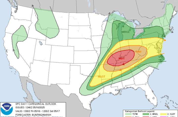
🌀 Midwest Storm Chasers – Day 1 Severe Weather Forecast📅 Valid: Friday, May 16, 2025 | 7:00 AM CDT – Saturday, May 17, 2025 | 7:00 AM CDT📍 Target Regions: Mid-Mississippi Valley, Ohio Valley, Tennessee Valley
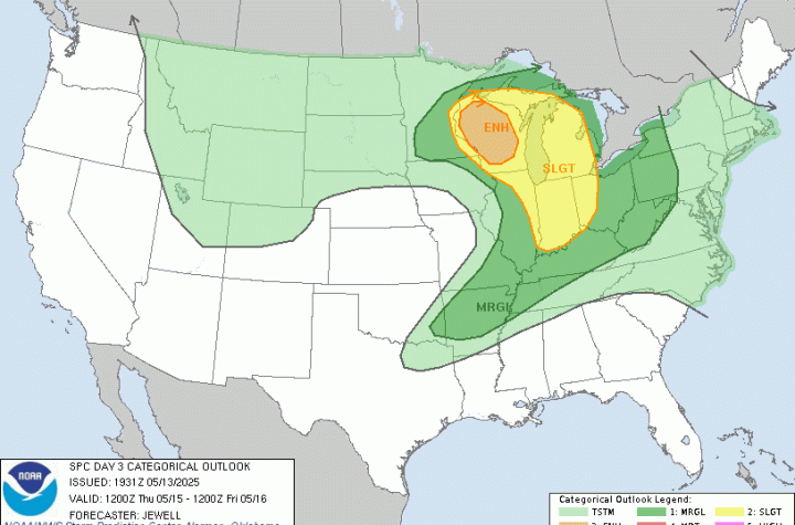
🌀 Midwest Storm Chasers Ops Desk Forecast📅 Day 3 Convective Outlook📍 Valid: Thursday, May 15, 2025 | 7:00 AM CDT – Friday, May 16, 2025 | 7:00 AM CDT📌 Issued: May 13, 2025 – 2:45 PM CDT📍 Lead Forecaster: Collin Leck