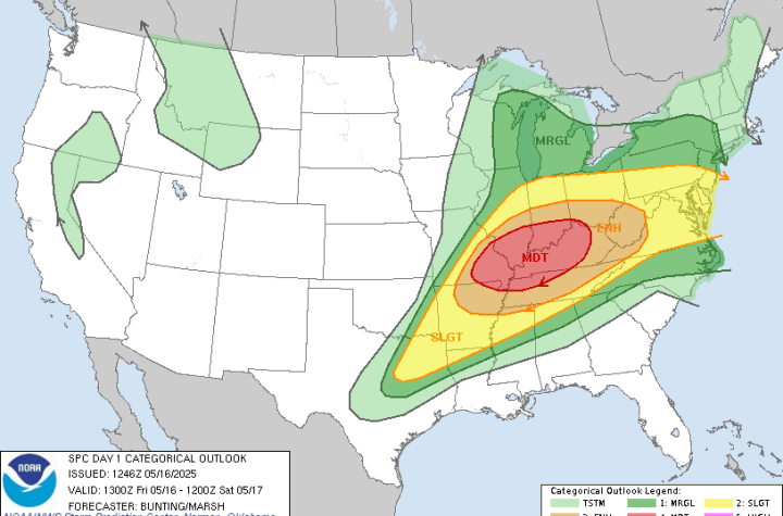
Issued by the Midwest Storm Chasers Team | Based on SPC Day 1 Outlook
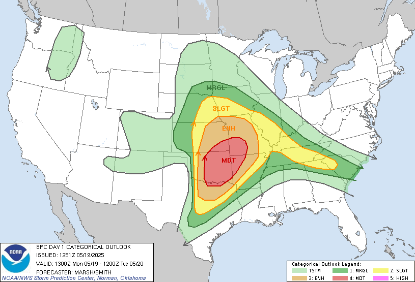
The Storm Prediction Center has issued a MODERATE RISK for severe weather today across far North Texas, central and eastern Oklahoma, southeast Kansas, and parts of the Ozarks.
This includes cities such as Oklahoma City, Tulsa, Wichita, Springfield, and surrounding areas.
🌀 Summary:
Multiple rounds of dangerous thunderstorms are expected from midday through late evening. All modes of severe weather are possible, including:
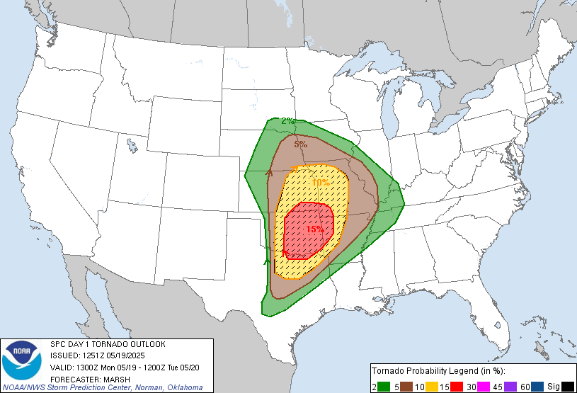
- 🌪️ Tornadoes, with potential for strong to intense tornadoes
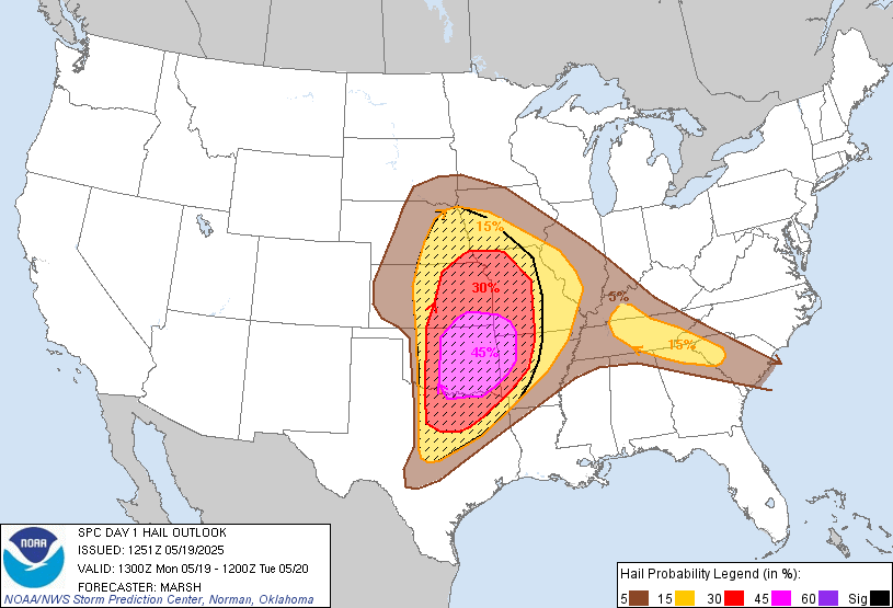
- ⚡ Very large hail, possibly exceeding 2 inches in diameter
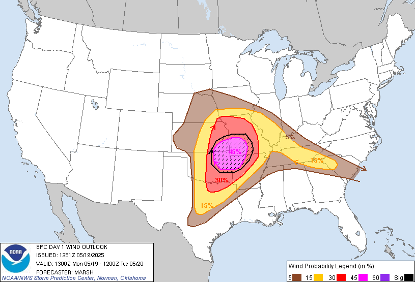
- 🌬️ Damaging winds, particularly across northeast Oklahoma into Missouri
📊 Atmospheric Conditions:
- Extreme instability (CAPE values of 3000–5000 J/kg)
- Strong wind shear with supportive low-level jet
- Enhanced mid-level flow approaching 70 knots
- A dynamic dryline setup in central OK/KS
⚠️ Forecast Highlights:
- Early storms may initiate by midday in eastern OK/KS
- Explosive supercell development likely late afternoon along the dryline
- Strong downdrafts and wind gusts expected in the Ozarks region
- Overnight storms possible further east with continued severe potential
📍 Stay Informed:
Monitor warnings, watches, and radar closely throughout the day.

More Stories
🌀 Midwest Storm Chasers – Day 1 Severe Weather Forecast📅 Valid: Friday, May 16, 2025 | 7:00 AM CDT – Saturday, May 17, 2025 | 7:00 AM CDT📍 Target Regions: Mid-Mississippi Valley, Ohio Valley, Tennessee Valley
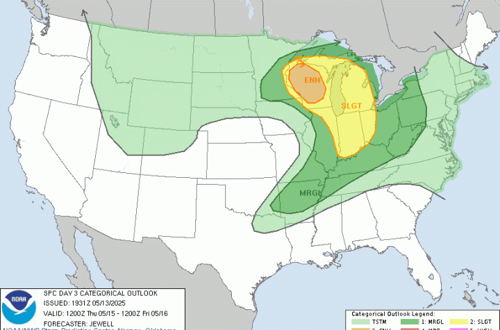
🌀 Midwest Storm Chasers Ops Desk Forecast📅 Day 3 Convective Outlook📍 Valid: Thursday, May 15, 2025 | 7:00 AM CDT – Friday, May 16, 2025 | 7:00 AM CDT📌 Issued: May 13, 2025 – 2:45 PM CDT📍 Lead Forecaster: Collin Leck
Severe Weather Outbreak Expected – Monday, April 28, 2025